
Unit 1
Major Geological Processes Associated with Plate Tectonics
Introduction
- Our planet Earth is the home of all living things in general and of human beings in particular.
- It is in constant motion, driven by internal and external forces.
- Humanity has always been affected by powerful natural forces such as earthquakes, volcanism, tsunamis, fires and fault ruptures, and the location of these forces is closely associated with plate boundaries, where plates diverge, converge and slide past one another.
- Knowledge of the Earth’s movements and of the forces behind them is therefore highly desirable, so that ground motion, earthquakes and volcanism can be predicted, the damage from moderate events minimised and total collapse avoided.
- You learned in earlier grades about the geological history of Ethiopia and the formation of the continents; this unit continues those lessons with the theories of continental drift and plate tectonics, the major geological processes, and the landforms they produce.
🎯 Learning Outcomes
- Explain the theory of continental drift and the controversies surrounding it.
- Describe the movement of the lithospheric plates over geological time.
- Explain the main types of plate boundary and how plates interact.
- Describe the driving forces that influence plate motion at different plate boundaries.
- Explain the major geological processes (internal and external) and the landforms they form.
- Explain the effects of the major geological processes on human lives.
1.1 The Continental Drift Theory
- The continental drift theory presupposes that the Earth’s continents have moved over geological time relative to one another, so that they appear to have ‘drifted’ across the ocean bed.
- The theory suggests that the present continents were formed from a single supercontinent called Pangaea (Greek: ‘all land’), surrounded by a single ocean, Panthalassa, with the Tethys Sea cutting into it from the east.
- During the Carboniferous period, some 350 million years ago, Pangaea was located around the South Pole.
- In the Triassic period of the Mesozoic era (about 200 million years ago) Pangaea started to break into several parts.
- The northern part is known as Laurasia (which became North America, Europe and Asia) and the southern part as Gondwanaland (which became South America, Africa, Australia, Antarctica, India and Arabia).
- Both were further subdivided into the present continents, and through the process of drifting the continents reached their present locations.
- The whole process took place over millions of years.
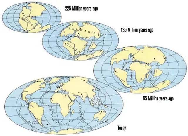
Geological evidence favouring the continental drift theory
- The concept was proposed by the German meteorologist Alfred Wegener in 1912.
- The basic idea that helped Wegener was that of a large united landmass consisting of most of the Earth’s continental regions.
- He introduced the supercontinent Pangaea to explain the ancient climate similarities, the fossil evidence and the similarity of rock structures between Africa and South America, as well as the outlines of the continents – especially the continental shelves – which seem to fit together.
- Wegener used the following geological evidence, among others, to support his theory:
🔒
The rest of Unit 1 is in the Danulearn app
Read the full notes for all 4 sections, worked examples and figures, plus 6 exercises with step-by-step solutions, the Short Note and the unit review.
📑 Contents
- 1.1The Continental Drift TheoryPreview
- 1.2Plate Tectonics Theory🔒
- 1.3Plate Movements and Plate Boundaries🔒
- 1.4Major Geological Processes🔒
✍️ Practice questions
5 questions from the Unit 1 quiz. Choose an answer, then check it.
- 1
Which of the following was proposed by Alfred Wegener?
- AIsostasy
- BContinental Drift
- CPlate Tectonics
- DSeafloor Spreading
Show answer
B Continental Drift
- 2
Which landmass formed the northern portion of Pangaea?
- ARodinia
- BGondwanaland
- CPannotia
- DLaurasia
Show answer
D Laurasia
- 3
The layer that allows the lithosphere to slide across the earth's surface is the:
- AAsthenosphere
- BInner core
- CMesosphere
- DOuter core
Show answer
A Asthenosphere
- 4
Which type of plate boundary is responsible for the formation of the Himalayas?
- AConservative
- BDivergent
- CConvergent (continent-continent)
- DTransform
Show answer
C Convergent (continent-continent)
- 5
The East African Rift Valley is an example of a landform produced at a:
- ATransform boundary
- BSubduction zone
- CConvergent boundary
- DDivergent boundary
Show answer
D Divergent boundary